
Day 11: Packwood
Journal for 2016-09-22 | Published on 2016-09-24 18:54:05It started raining at some point during the night, so Matt had to get up and make sure all our panniers were closed up tight, and our seat covers were on our bikes. It didn’t rain much, and everything was dry by morning. It was a bit cool when we got up at our usual time, but not as cold as yesterday morning, thank goodness. We ate breakfast and broke camp and started riding about 830. Continuing up the canyon, up and up and up toward the pass. We stopped as we needed to snack and take breaks, once stopping at a little store to pick up an energy drink. Eventually we reached the source of the Tieton River-a reservoir called Rimrock Lake. After riding through a short tunnel, we could see the reservoir, which wasn’t nearly as picturesque as some of the other lakes we’ve seen due to its low level. It’s used as storage for agriculture water which is needed during the dry summer months, additionally in recent years the lake has become a popular recreation lake.
Moving on, we enjoyed a brief respite from the climbing as we rode alongside the lake. As we were riding along the lake we heard a military jet and turned to watch a single jet fly along the lake at very low elevations, probably only 100-200ft above water level, it was pretty exciting to see. We’re pretty close to Joint Base McChord-Lewis, so we weren’t too surprised to see military aircraft. Then we began the climb up to the pass in earnest. Just as we started up, a gentleman yelled some encouragement to us, and informed us that we had just started the climb. Yep, we know. In fact, we’ve pretty much been climbing all day today, and most of yesterday, but thanks for pointing that out to us! At least he was friendly! (Actually, most people have been super friendly on this trip. I’m grateful for that.)
The climb up from Rimrock Lake was a sight to see, the road simply cut into the side of the cliff going off into the distance. Due to an extra pop tart with our usual breakfast of oatmeal, we actually weren’t hungry at our normal time of 1130. We decided to see if we could make it to the top for lunch, and if we were short of that, there would be a waterfall view that would make a good lunch spot. As we climbed higher and higher, we could see Clear Lake below us, and the scenery just kept getting prettier. There were high cliffs with waterfalls trickling down off to our right, and valley with more cliffs and trees off to our left. At one point we saw a group of military helicopters fly over.
We made it to the waterfall overlook, and had a nice lunch of pb&j, and chatted with some fellow travelers who wished us happy trails. Then it was up for the last few miles to the top. Finally! White Pass elevation 4500 ft! And our second crossing of the Pacific Crest Trail.
There was a little store at the top, and we decided that we needed a little extra food to keep us going down the road, so we pulled in. The store is a popular place for PCT hikers to get packages, and we were lucky enough to meet two thru hikers excitedly going through their boxes. One hiker, the girl, had been hiking since early May. They have a little over 400 miles left to go on their hike. We swapped a few stories about each of our travels, and they each had some extra food from their re-supply boxes so we took it off their hands and the wished them the best of luck on their epic journey!
When we felt like we had rested enough, we climbed back on the bikes, but not before bundling up once again, knowing that the next 20 or so miles would be downhill. And they certainly went by somewhat fast, unfortunately a nasty headwind started pushing against us, slowing us down to 20mph on 6% down grade, which is very slow, but still it was an enjoyable downhill. We pulled into the scenic view pullouts, but Rainier was shrouded in clouds today. We got to see the Palisades, a cool formation thought to be formed when a lava flow came up against a glacier. It started to rain while there, so we hurriedly got back on the bikes and rode downhill and out of the rain. And then, suddenly, it was time to change maps! Yeah, that’s right. We’re now on map 2 of the ACA maps. As we were changing out the maps, a car was stopped by the side of the road, and they rolled down their window, “How do you get to Seattle from here? My GPS doesn’t work.” LOL, lady. Let me see…I actually didn’t have too much of an idea, other than the highway we were on would eventually run into Interstate 5, so that’s what I told her to do. Sometimes I think GPS is more trouble than it’s worth. It’s great, until it doesn’t work and no one has bothered making a plan or looking at an actual map. But, leave it to the bicycle tourists to have a general idea of the geography of the area and hook you up.
Once we changed maps, it was about 7 downhill miles to Packwood, but those were pretty hard fought downhill miles as we once again encountered a gusty headwind, our speed rapidly bounced from 14mph to 7mph and all over in between as the gusts pushed against us. We made pretty ok time, but it was still more work than it should have been. We rolled into town, got cheered on by more PCT hikers who saw us riding through, found the grocery store, stocked up, and decided the best course of action would be to continue 7 miles further to an RV park. So, that’s what we did, contending with the headwind, but we made it. We ended up getting a room in the hostel, as it was only a few dollars extra, and it might rain tonight.
Dinner was thin spaghetti with alfredo sauce, and the shower sure felt nice. Looks like we have a couple of days with minimal services coming up, so we’ll have to make sure to plan it out. Randal is about 8 miles away, and our last chance for groceries for about 73 more miles. There’s plenty of campsites along the way, we should be good, but will likely be out of contact
We’ll be riding past Mt. St. Helens tomorrow, but if the weather is anything like today, we probably won’t get much of a view. Ah, well. Maybe next time!
Distance: 54.55
Avg: 9.9
Max: 30.3 should have been much higher with long 6% downgrades, but alas the wind said no
Climb: 2710ft
Time: 5:29:07
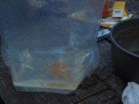
After a night of settling this is what was in our water container... gross.
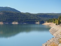
Rimrock Lake, heavily drained after a summer of use.
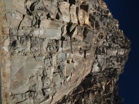
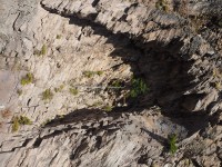
They bolted the rocks to deeper rocks so they wouldn't fall on us...
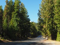
Pine forest lined roads on Highway 12
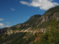
Look at the long climb along the cliff
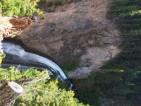
Nature will find a way, such as this tree in the cave
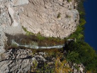
One of many waterfalls we saw climibing
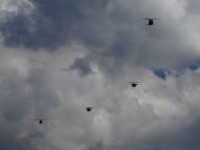
Military helicopters flying above us.
Clear Creek Falls just off Highway 12
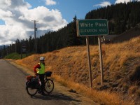
Another pass down!
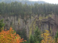
Pallisades Viewpoint, formed by lava cooling next to a glacier!
We drove White Pass a few years ago coming back from Portland. It sure is beautiful! You are right, you can get to Seattle from there. LOL love you guys!