
Day 15: Sherwood Campground
Journal for 2016-09-26 | Published on 2016-10-02 07:57:47Today started off well, with a hearty breakfast of pancakes and bacon, with yogurt. We packed up all our stuff and headed out a little after 8. Our goal was to make it as far past Parkdale as possible, up into the forest. Let me tell you, just when I felt like I had this bicycle touring thing under control, it throws us a curveball. Namely, Oregon roads. See, Washington roads involved a lot of climbing, but it was typically 3-8% grades, which is totally doable. Heading out of Cascade Locks, we were hitting grades upwards of 14%. Tough!
Finally, we got a reprieve while we rode along the shoulder of Interstate 84. I know it sounds dangerous, but this wasn’t too bad. It definitely wasn’t the busiest road we’ve ridden along. There were some tense moments when we lost our wide shoulder, but it lasted only ½ mile, and was over quickly enough. We took a side detour between two state parks, taking advantage of a bicycle path that may one day be complete all the way from Hood River to Cascade Locks, they are just finishing up the section from Lindsey Creek to Starvation Creek, but already are done beyond Starvation Creek. That will be cool.
It took us 20 miles to reach Hood River, and we stopped at the Walmart first to pick up some supplies as we are heading into areas with minimal services. We caught our first glimpse of Mount Adams, off to the north. And then we made a pit stop at Rite Aid to fill a prescription. Finally, we headed out of town, through the cute downtown area of Hood River. Our goal was to stop for lunch at the county park a few miles out of town. We started out on the highway 35, but then turned left and climbed up, and up, to the park, which is complete unmarked, and a panoramic view of Mount Hood.
Mt. Hood is the highest peak in Oregon at approx. 11,420ft, apparently there is some dispute about its actual elevation. Pretty awesome mountain. The sky was clear blue, and we had an amazing view all day as we drew closer. We chatted with a couple from Texas who were visiting the area, and they seemed really interested in touring. I hope someday they give it a shot!
The route we are following took us away from the highway as much as possible, and actually had us climbing less than the highway. We were riding on back country roads, through orchards, with views of both Hood and Adams to reward our hard work. And it was hard work. At one point, our road was closed, so we had to take an alternative, and it was a very steep climb to the top of a little hill. There was very little flat or downhill riding today and it was much hotter than we have been accustomed to. Temps peaked in the upper 80’s and in sun, pedaling uphill, it felt oppressively hot.
Eventually, we made it into the last little town, Parkdale, with services for a while. For being a town of 311 people it was surprisingly well stocked with a nice grocery store, brewery, restaurant, and ice cream shop / burger joint. We stopped at the grocery to stock up on water, and then went to the ice cream shop for a little pick-me-up in the form of huckleberry ice cream (for Pam) and a root beer float (for Matt).
We had about 11 miles left to go, it was going on 4 o’clock, and we knew we just had to bite the bullet and crank out the last miles. It was our understanding that the campgrounds in the area are all closed since that is what the forest service website says, and none have water save for the rivers or streams (we have a filter, so no worries there). However, as we finally ground out the last of the miles and pulled into the campground, a FS worker pulled in behind us and we were pleased to find that the campground is open! The worker told us that most still are, until next weekend, and even the closed ones, we can camp at, we just may not have TP in the restrooms, and will have to carry out our own garbage. Good to know.
At one point in the ride today, Pam commented that we had to fight for every mile today. And it was true! Oregon roads sure are going to test our limits. At least it’s pretty.
At the campground, since there’s no running water, both of us decided to rinse off in the glacial melt river, which was more cold than invigorating, but at least we got most of the salt knocked off. Did I mention it was hot today? Much higher temps than we’ve been riding in lately, and it took more energy than it would have otherwise. So we were pretty sweaty by the time we rolled into camp. Dinner was rice and broccoli w/ cheese, and ham, which was really tasty. And then after we cleaned up, we enjoyed a dessert of a Heath candy bar. Now it’s time to sleep, and get recharged for tomorrow. Looks like our options for campgrounds are 38 miles (that would be a short day) or 72 miles (that would be a really, really long day). We’re going to just have to play it by ear, and we may be dispersed camping for the first time, we’ll see.
Time: 6:12:38
Distance: 51.29
Average: 8.2
Climb: 4869
Max: 31.2
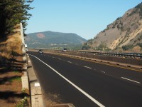
The section of "narrow shoulder" on I-84. It is narrow, but not unridable.
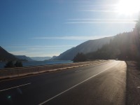
I-84 heading to Hood River
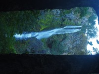
Starvation Falls
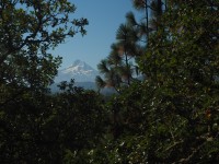
First glimpses of Mt. Hood
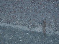
Another "stick" on the ground that moved
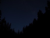
Stars over the trees
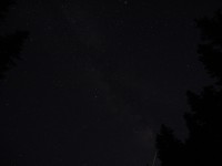
More stars
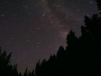
A 6 minute exposure showing the earths rotation
Yummy huckleberry!