
Day 30: Rancheria RV Park, Hat Creek, CA
Journal for 2016-10-11 | Published on 2016-10-12 21:01:08Boy was it cold when we got up this morning, just a little above freezing. That wasn’t what Pam expected, so she hadn’t put on all her thermals last night, so getting up to go to the bathroom was more than a little uncomfortable. Our new normal is getting a late start, and today was no different. We finally finished breakfast and broke camp and got on the road around 8:30. We had already seen the lower falls, and planned to see the middle and upper falls of the McCloud River.
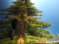
About 2 miles into the ride was the lookout for Middle Falls. Very pretty, the overlook is high above the falls. We rode on, and came to the Upper Falls overlook. It was a little bit off route, but we were determined to see ALL of the falls. While Pam used the outhouse, Matt went to find the falls, and was almost disappointed, because all he found were some ripples. Well, the falls were further downstream, and when we finally found them, we were both impressed. Very pretty spot, I’m glad we stopped.
Then it was onward, finishing up our river loop with temperatures already 15F warmer than when we started, and then it was back onto the very busy Highway 89, the one with no shoulder and 65mph speed limits. We were definitely climbing up in elevation, but through the means of very big rolling hills. It seemed like we would gain so many feet, only to lose most of them coming down the other side of the hill. It was a net positive gain, though, and eventually we started the real climb up to Dead Horse Summit. We passed a little café, but were disappointed to find it wasn’t open on Tuesdays. Matt really wanted a piece of pie. Hmm…
Well, we made our way up to the summit for the day, and had lunch right at the top. It would have been extremely pleasant, except for the yellow jackets that seem to find us wherever we stop. The treat of the meal was muddy buddies, which are Chex dipped in chocolate & peanut butter, then coated in powder sugar. Yum.
After the summit, we had undulating hills in the downward direction, and then a nice 6% downgrade for a few miles, where we caught our first glimpse of Lassen Peak, the last Volcano in the Cascades. When we finally reached Shasta County, we were rewarded with a nice 4-6’ shoulder. It made riding so much more enjoyable to not have to look behind us constantly and bail off the road when big trucks come our way. We even took a “shortcut”. The route suggested a side road that would take us up and around a reservoir, but since the road was really nice that we were on, we decided to shave off that one mile of riding, and cut off a bit of climbing to boot. Unfortunately, shortly after the turn off we were supposed to take we lost our shoulder and were back to constantly ducking off the road to avoid high speed semi’s. Even with that it was shorter and less climbing.
Since the weather is going to close in on us very quickly, we want to make sure we get over Lassen summit tomorrow, so every mile we ride today is one less we need to do before the summit. So, we pushed on a bit harder toward the end of the day than we normally do, to reach this campground a few miles short of Old Station. We will have 40 or so miles up to the top of the summit tomorrow, which will be more than 4000 ft of elevation gain. The ride is shaping up to be a lot like our Washington Pass ride, only this time our legs are stronger. The weather is supposed to be clear tomorrow, so we should get some good views of the volcano and the recent (1915) eruption.
The RV park we’re staying at had a restaurant that was still open when we got here, so we splurged on dinner, very nice Mexican food. There’s also hot showers, so we were able to scrub the grime from the last two days off. We have a nice little tent site, away from everyone else, and are just about to enjoy a piece of peach pie before we turn in. It’s hard to believe we’ve been on the road for 30 days.
More & more it looks like we are going to be wrapping this tour up shortly. This series of storms moving through is expected to drop 3-8 inches of rain in the mountains over 4 days. We don’t want to just sit in a hotel or our tent and wait, nor do we want to ride in that, so we may just rent a car and head home to enjoy some down time before returning to our normal lives. But first, Lassen Summit!
Time: 5:21:06
Distance: 59.6
Average: 11.1
Climb: 3077
Max: 32.6
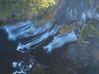
Middle falls
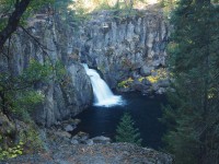
Upper falls front side
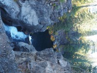
Upper falls from the back side
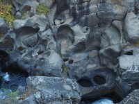
Some of the errosion in upper falls
McCloud River before upper falls
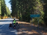
Pam at Dead Horse Sumit
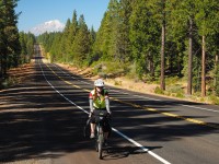
Pam enjoying the wide shoulders in Shasta County
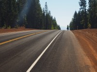
Pam sumiting a rolling hill
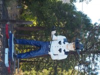
A "muffler man" named Roy.
https://www.youtube.com/watch?v=12QQV3lyYj0 all about cherry pie and coffee "i plan on writing an epic poem about this gorgeous pie" Gordon Cole, (actor David Lynch) Twin Peaks